Other Services

Visualise Location With Greater Clarity
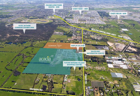
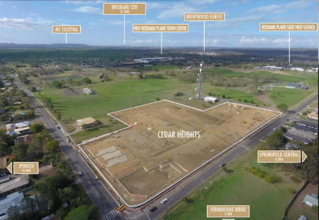
Maps and aerial maps help buyers understand more than just the property itself. They provide valuable context by showcasing surrounding amenities, transport links, neighbourhood features, land boundaries, and points of interest that influence purchasing decisions.
Property Visuals 360 creates professionally designed maps and aerial maps that help communicate location advantages clearly and effectively.
Showcase Location Advantages
Highlight nearby schools, transport routes, shopping districts, business hubs, and local attractions.
Improve Property Understanding
Help buyers visualise where a property sits within its surrounding environment.
Support Marketing Presentations
Maps provide valuable visual context for brochures, websites, presentations, and investment materials.
Enhance Property Listings
Professionally designed maps help properties feel more informative and easier to evaluate.
Why Maps Matter?
Location remains one of the most important factors in real estate. While property photos showcase the building itself, maps help explain why the location is valuable.
Professionally designed maps make it easier for buyers, investors, and stakeholders to understand access, proximity, and surrounding infrastructure, helping them make more informed decisions.
Key Elements Of Professional Maps & Aerial Maps
Designed to communicate location information clearly while maintaining a professional visual presentation.
- Custom location maps
- Aerial property mapping
- Boundary highlighting
- Points of interest identification
- Transport and accessibility mapping
- Neighbourhood overview maps
- Development site mapping
- Branded visual presentation
- Print and digital compatibility
- Marketing-ready delivery
Professionally designed maps help strengthen property marketing while providing valuable location context for buyers and investors.
Frequently asked questions
01What is the difference between a map and an aerial map?
A standard map focuses on location and surrounding infrastructure, while an aerial map uses overhead imagery to provide a visual perspective of the area.
02Why are maps useful in property marketing?
They help buyers understand the property’s location, nearby amenities, transport access, and surrounding environment.
03Can property boundaries be highlighted?
Yes. Property lines, lot boundaries, and development areas can be clearly identified.
04Can points of interest be added?
Yes. Schools, shopping centres, parks, transport links, and other landmarks can be highlighted.
05Are aerial maps suitable for land sales?
Yes. Land, acreage, subdivisions, and development sites often benefit from aerial mapping.
06Can maps be branded?
Yes. Colours, typography, logos, and brand guidelines can be incorporated into the design.
07Are maps suitable for Offering Memorandums and brochures?
Yes. Maps are commonly used within brochures, presentations, market reports, and investment documents.
08Can multiple properties be shown on one map?
Yes. Multiple locations, development stages, or project areas can be displayed together.
09Can existing maps be redesigned?
Yes. Existing maps can be modernised and redesigned to improve clarity and presentation.
10Who benefits from professional maps and aerial maps?
Agents, developers, investors, brokerages, property marketers, and businesses presenting real estate opportunities.